-
Pinehaven Flood Hazard Information Sheet and Map 8
This information sheet covers the current flood hazard extent for the Pinehaven Stream Catchment that was identified in Phase 1 of the joint Upper Hutt City Council and Greater Wellington…
alarm Published 01 Jun 2010 -

Pinehaven Flood Hazard Information Sheet and Map 3
This information sheet covers the current flood hazard extent for the Pinehaven Stream Catchment that was identified in Phase 1 of the joint Upper Hutt City Council and Greater Wellington…
alarm Published 01 Jun 2010 -

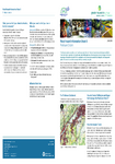
Pinehaven Flood Hazard Information Sheet and Map 1
This information sheet covers the current flood hazard extent for the Pinehaven Stream Catchment that was identified in Phase 1 of the joint Upper Hutt City Council and Greater Wellington…
alarm Published 01 Jun 2010 -

Pinehaven Flood Hazard Information Sheet and Map 8
This information sheet covers the current flood hazard extent for the Pinehaven Stream Catchment that was identified in Phase 1 of the joint Upper Hutt City Council and Greater Wellington…
alarm Published 01 Jun 2010 -
Proposed Regional Policy Statement for the Wellington region May 2010
“Decision version” of proposed Regional Policy Statement (2010)
alarm Published 31 May 2010 -
Decisions Report: proposed Regional Policy Statement for the Wellington Region 2010, Volume 2
Includes decisions on submissions on the proposed Regional Policy Statement from policy 20 to end
alarm Published 31 May 2010 -
-
-
Pinehaven Stream Flood Hazard Assessment Volume 1
Purpose of the report: To identify flood risks and assess hazards in the Pinehaven Stream catchment using hydraulic modelling and related analyses.
Geographic Area: The Pinehaven Stream catchment, located on the…
alarm Published 25 May 2010 -